
A facilities team at a UK food or retail operator usually already knows which stores or warehouses have flooded before. What it rarely has is a single, estate-wide view that adds heat, wind and water stress to that picture, or a number finance will act on. A five-step physical climate risk assessment closes that gap. Following it, a team names every hazard that threatens trade across the estate, ranks sites by financial exposure and arrives at an adaptation plan a property director can fund.
What does a physical climate risk assessment involve for a food or retail multi-site estate?
A physical climate risk assessment for a food or retail multi-site estate follows five stages: hazard identification, exposure and vulnerability mapping, deciding where a site needs an on-site survey, financial quantification and adaptation planning, run across every site rather than one flooded location at a time. Read together, they take a team from "we know some sites flood" to a ranked, funded plan. This guide adapts the same physical climate risk framework used across other sectors specifically for food and retail. The Climate Change Committee's independent assessment of UK climate risk names flood, heat and water scarcity among the priority risks facing UK infrastructure and supply chains over the next five years, which is one reason to treat these hazards as one assessment rather than four separate exercises. The government has backed that assessment with money as well as words, ringfencing £1.4bn of flood defence funding for 2026/27 to protect homes and businesses, part of a wider £10.5bn programme running to 2036.
Each stage does a distinct job:
Step 1, hazard identification: Your team names every hazard that threatens continuity of trade across the estate, not flood alone.
Step 2, exposure and vulnerability mapping: Your team maps site and asset-level detail rather than relying on an estate-wide average.
Step 3, the survey decision: Your team decides where a desktop assessment is enough and where a site needs an on-site engineering survey.
Step 4, financial quantification: Your team converts the multi-hazard picture into an annualised figure and an event cost.
Step 5, adaptation planning and business-case reporting: Your team ranks adaptation measures by return and packages the result for finance and insurers.
type: embedded-entry-inline id: 5oQQLqr3606KEpXnFNoM8R
Which climate hazards matter most for retail and food supply chains beyond flooding?
The climate hazards that matter most for retail and food supply chains beyond flooding are heat, wind and water stress, each with a different failure point across a multi-site estate. Flood is usually the hazard already on a facilities team's radar, since known flood-risk sites tend to get managed, even if reactively, well before heat, wind or water stress do. The three hazards below are where most estates still have a blind spot, and the Met Office's UKCP18 UK Climate Projections show both extreme-heat days and peak wind gust risk increasing across the UK through 2050, which is a large part of why an assessment that stops at flood exposure increasingly misses real financial risk.
Each hazard carries a different failure point:
Heat: Extreme-heat trading days reduce footfall at retail sites and raise failure risk in the cold chain for chilled and frozen stock, a consequence specific to food retail rather than a generic comfort issue. Heat also puts sustained load on in-store cooling systems, and at sites where cooling capacity falls short, it becomes a health and safety risk for staff and customers, not just a stock-loss one.
Wind: Roofing, signage and external structures carry the highest financial exposure, concentrated at older sites or those with deferred maintenance.
Water stress: Water-dependent ingredient processing and supply is exposed where a site's operation, or a supplier's, depends on a consistent water source.
These hazards also compound. A hot, dry summer that lifts footfall risk at retail sites can simultaneously push water stress at a food-processing site further up the supply chain, so an estate that only tracks one hazard at a time can miss the combined event that actually drives a bad quarter. Heat adds pressure of its own: it disrupts the travel routes staff and customers rely on to reach a site, and when extreme heat closes local schools, staff without childcare cover are pulled from the rota at the same time footfall and travel disruption peak, stretching the store's ability to respond.
How do you map exposure and vulnerability across stores, warehouses and supply chains?
Mapping exposure and vulnerability across stores, warehouses and supply chains means answering two different questions for every site: what sits in the hazard's path, and what happens if it is hit. Exposure and vulnerability are not the same measurement, and an estate-wide average hides the difference between a flooded car park and a flooded chilled warehouse.
In practice, that means:
Exposure mapped at asset level: Your team records what sits at each site, a store, a chilled warehouse, a distribution hub, rather than a single postcode-level score for the whole estate.
Vulnerability assessed by site type: A store losing footfall for a day and a warehouse losing a chilled stock line carry different financial consequences, so the assessment scores them separately.
Ownership assigned across tiers: Property typically owns store and warehouse-level exposure, while procurement owns exposure sitting with a supplier, so the mapping stage should flag which team acts on each finding. Exposure that sits with a supplier and has no named owner tends to stay unaddressed until the supplier itself fails.
Estates that try to run this stage manually usually do it store by store, in whatever order a regional manager raises a concern. That approach produces a pile of individual site reports rather than a ranked estate-wide view, and it is the point where most operators either stall or bring in an automated mapping tool to cover every site on one consistent basis.
When does a site need an on-site engineering survey rather than a desktop assessment?
A site needs an on-site engineering survey rather than a desktop assessment once its modelled exposure or asset value crosses a materiality threshold, or once local conditions cannot be resolved from hazard data alone. A desktop assessment, drawing on sources such as the Environment Agency's long-term flood risk service for flood exposure, is enough to triage and rank the whole estate; a survey answers questions the model cannot, for example the actual condition of a flood defence, the age of a roof structure, or whether a chilled warehouse has backup power sufficient to ride out a multi-day outage.
Practical tip: Start the on-site survey list with the sites carrying the highest combined exposure and asset value, not with whichever site flooded most recently. A site that has never flooded can still carry the estate's highest wind or heat exposure.
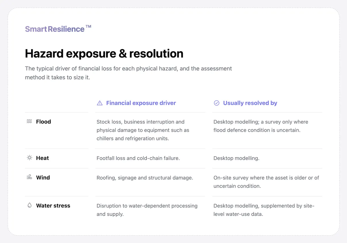
In most estates, only a minority of sites need a physical survey. The rest can be triaged and ranked from desktop data alone, which keeps the assessment moving instead of stalling on a long queue of site visits. Here is how the four hazards typically resolve, and what usually decides desktop versus survey:
How do you quantify the financial cost of a weather event across a multi-site estate?
Quantifying the financial cost of a weather event across a multi-site estate means converting the vulnerability findings from the earlier steps into two figures: an annualised expected loss and the cost of a specific return-period event, aggregated across every hazard and every site. PCRAM, the Physical Climate Risk Appraisal Methodology governed by the Institutional Investors Group on Climate Change (IIGCC) since 2023, sets out the standardised approach behind this step in more detail.
What good looks like:
An annualised expected loss per site: A single figure your finance team can compare directly against the cost of a mitigation measure. It answers the question a budget-setting conversation actually starts with: what costs should we expect in a typical year?
A cost at a material return period: The financial impact of, for example, a 1-in-100-year event, alongside the annualised figure, since a board weighs the two differently and an insurer's excess level is usually set against an event of a similar severity. It answers a different question: how costly would a really bad event be, at the plausible worst case?
One aggregated figure across hazards: The estate total combines flood, heat, wind and water stress rather than reporting four figures your finance team has to add up itself. It answers the estate-wide question: how exposed are we, in total, across every site?
Aggregation matters as much as the individual figures. A board reviewing capital requests wants one portfolio-level exposure number it can track year over year, not four hazard-specific reports it has to reconcile itself before an adaptation budget can be compared against any other line item.
How do you turn the assessment into an adaptation plan and an insurer-ready business case?
Turning the assessment into an adaptation plan and an insurer-ready business case means ranking adaptation measures by return on investment against the highest-exposure sites, then packaging the methodology and the figures into evidence your finance team and your insurer can both use. A ranked, funded plan is what separates this step from a report that lists risks without a next action.
What to check:
Measures ranked by return, not by hazard severity alone: A low-cost drainage fix at a high-traffic site can outrank an expensive retrofit at a lower-risk one.
A sequence, not a flat list: The plan should show which sites get funded first and why, tied directly to the exposure figures from the previous step.
An evidence pack ready for insurance renewal: Documented methodology, assumptions and any mitigation already taken give your team something concrete to bring to a renewal conversation, not just an internal risk report.
A defined review point: Since exposure changes as the estate and the climate data both evolve, the plan should state when it gets revisited rather than treated as a one-off document. A new lease, an acquisition or an updated hazard model are all reasonable triggers to bring the review forward rather than waiting for the next scheduled cycle.
How SmartResilience helps you quantify physical climate risk across a food or retail estate
Most food and retail teams reach the same wall after mapping flood, heat, wind and water stress by hand: a hazard rating for every site and still no single financial figure across the whole estate. SmartResilience Climate Assessments closes that gap for flood today, extending coverage to the remaining hazards as that work develops:
A financial figure per site: The platform reports an annualised expected loss and an event cost for flood exposure today, with heat and water stress quantification in development.
Adaptation measures ranked by return: Your team sees which measures pay back and over what period, so a capital request carries a number rather than a recommendation.
An evidence pack behind every figure: The methodology and data lineage sit behind each number, giving your team a pack ready for an insurer renewal conversation as well as an internal budget request.
Sainsbury's runs this across 1,000+ sites and avoided a £3m flood damage event when the same town flooded twice, seven years apart, with opposite outcomes.
SmartResilience
See SmartResilience in action
Book a free demo tailored to your organisation and assets.
Book a free demoWhat next?
The next flood, heat wave or storm across your estate is not a question of if. Whether it costs six weeks of trading and an expensed repair bill, or gets absorbed inside a plan your finance team already signed off, depends on whether the assessment behind it covers every hazard your sites actually face, not just the one that flooded last time.
FAQs
What are the steps in a physical climate risk assessment for a food or retail business? The five steps are hazard identification, exposure and vulnerability mapping, deciding where a site needs an on-site survey, financial quantification and adaptation planning, run across every site in the estate rather than one location at a time.
Which climate hazards matter most for retail and food supply chains beyond flooding? Heat, wind and water stress each carry a distinct financial consequence: heat through footfall loss and cold-chain failure, wind through roofing and signage damage, and water stress through disruption to water-dependent ingredient processing.
How do you quantify the financial cost of a weather event across a multi-site estate? Quantification converts hazard and vulnerability findings into an annualised expected loss and the cost of a specific return-period event, aggregated across every hazard and every site in the estate, rather than modelled hazard by hazard in isolation.
When should you get an on-site engineering survey? Once a site's modelled exposure or asset value crosses a materiality threshold, or local conditions such as flood defence condition or roof age cannot be resolved from hazard data alone, a survey replaces the desktop estimate with a measured one.
How does a retailer turn an assessment into an insurer-ready business case? By ranking adaptation measures by return on investment against the highest-exposure sites, then packaging the methodology, the figures and any mitigation already taken into evidence an insurer can use in renewal negotiations.
How is a multi-hazard assessment different from a flood-only assessment? A flood-only assessment ranks sites by one hazard. A multi-hazard assessment adds heat, wind and water stress to the same sites, so a site with low flood exposure but high heat or wind risk does not get missed.
How long does a physical climate risk assessment take for a multi-site estate? Timelines vary with estate size and how much of the desktop stage is automated, but a food or retail estate can typically move from hazard identification to a financial figure well inside a single budget cycle.
Do you need to assess every site, or can you sample the estate? Every site needs at least a desktop pass, since exposure varies enough between neighbouring sites that a sample can miss the estate's highest-risk locations. Sampling is only reliable for deciding which of the flagged sites need a full on-site survey.